

The Department of Defense (DoD) has stopped transmitting real-time microwave data from three weather satellites critical to hurricane forecasting. The data feed, gathered from the Special Sensor Microwave Imager Sounder (SSMIS) onboard satellites jointly operated by the DoD and the National Oceanic and Atmospheric Administration (NOAA), will officially cease by Monday, June 30.
This decision, communicated through a formal NOAA service notice on Tuesday, marks a major loss for meteorologists, particularly those tracking hurricanes forming over open oceans—areas where direct observation is sparse or nonexistent. The microwave imagery provided by SSMIS has been used for years to monitor storm structure, gauge intensity, and identify rapid changes in tropical cyclones.
A Major Setback in Hurricane Forecasting
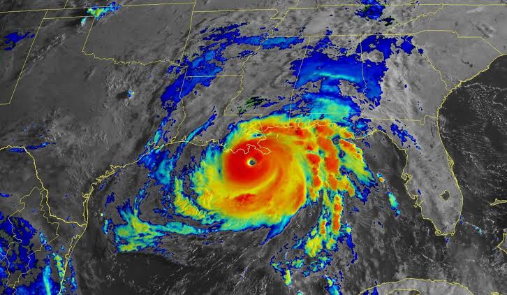
Microwave satellite data offers a unique capability: it can peer through thick cloud cover to detect critical features inside a storm that infrared and visible satellites cannot see—especially overnight when conventional satellite tools are limited. Without this resource, meteorologists say forecasting accuracy will suffer.
Forecasters are particularly concerned about the risk of missing episodes of rapid intensification—a phenomenon where a storm strengthens dramatically in a short period. Microwave data also helps determine the precise center of a storm, a seemingly small detail that plays a major role in shaping the accuracy of long-range forecasts. Even a minor misplacement of a storm’s center at the start of a forecast can lead to large trajectory errors days later.
Disruption Comes Without Warning
The weather and climate science communities were caught off guard by the announcement. Officials at the National Hurricane Center (NHC), one of the primary users of the data, received little advance notice and are now working to adjust to the abrupt loss during an already active hurricane season.
This is particularly troubling because hurricane hunter aircraft, which provide direct measurements of storm conditions, are only used in a fraction of forecasts—about one-third in the Atlantic and far fewer in the Pacific. That makes satellite-based data not just important, but indispensable.
While some microwave data will still be available from other satellite systems, the now-discontinued SSMIS feed represented roughly half of the total global microwave coverage available to forecasters. This sudden drop will significantly reduce the number of high-quality observations meteorologists receive each day.
Broader Climate Implications
The impact extends beyond tropical cyclones. SSMIS data also supports polar climate monitoring, including sea ice measurements, and is used in weather models globally. Additionally, advanced tools like the Deep Multispectral INtensity of Tropical Cyclones estimator (DMINT)—which uses artificial intelligence to estimate storm intensity—heavily depend on microwave imagery from satellites like those recently shut down.
The interruption of this data source weakens not just U.S. hurricane forecasting but also global efforts to track and model weather and climate patterns accurately.
Security Concerns Behind the Cutoff
While no official explanation has been provided for the termination, the decision is believed to be linked to internal security concerns within the Department of Defense. Details remain unclear, and the move appears to have been made without significant coordination with NOAA or other civilian forecasting agencies.
The lack of transparency and the absence of a readily available replacement have sparked widespread concern among meteorologists, emergency planners, and researchers who depend on this data for real-time weather decisions and long-term climate modeling.
A New Satellite Offers Hope, But Access Remains Uncertain
The DoD successfully launched a new weather satellite in April 2024—the Weather System Follow-on Microwave (WSF-M)—which is designed to carry on the legacy of SSMIS. However, data from this satellite is currently not accessible to NOAA or other civilian forecasters, and no timeline has been provided for when or if that access will be granted.
Until WSF-M data is made available or alternative sources are found, experts warn that the forecasting community will be operating with diminished capabilities at a time when accuracy and lead time are most critical for public safety.


