

Google has been working to bring useful and resourceful features for the people since the beginning of 2020, but how to get around amid a pandemic? A new feature to the Google Maps application is incorporated by Google, a new layer that works to bring the number of COVID-19 cases in a specific area in the foreground. This feature can be very useful for people to make informed decisions on where to go and where not to go during these hard times.

Google will add this feature as a layer in the Google Maps app. The users will get a message displayed, something like ‘See COVID-19 Information’ by tapping on the layer icon. ‘Map details will show this new feature with a warning icon.
This means that now, the user will be able to see COVID-19 outbreak in your area or anywhere else. Similar to how the users can view the level of traffic in a specific area or on a particular road. This feature can help you make an informed decision if you wish to visit a place for holiday or business, anything.
This feature will initially work in 220 countries, including India.
The scope of this feature will also help users to analyze the increase and decrease in COVID cases during Summer and Winter season.
HOW WILL THIS FEATURE WORK?
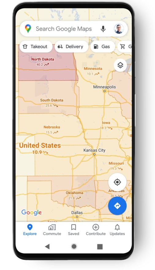
Tapping on the layer icon, Google will show a seven-day average of new COVID-19 cases per One Lakh people for the area of the map, the user intends to look at. The User Interface is themed differently than the regular real-time location interface. The feature has used a different colour coding so that the users can easily distinguish between the density of cases in that particular area they are looking at. Each geographic section is separated and Google also notifies when the overall cases rise or fall in a specific area.
As per reports, Google is said to retrieve this data from public health organizations like the WHO- World Health Organization, local government health ministries and local health hospitals and agencies.
HOW TO USE THIS NEW FEATURE?
Once this update arrives on your device, you will be able to use the insights of this incredible feature by following the below-mentioned steps:
- Update your Google Maps.
- Open Google Maps.
- Tap on the Layers icon (square on a square icon)
- Now, the user will see an overall map of COVID-19 cases in the world, colour- coded by severity.
This update on Google Maps will roll out worldwide on Android and iOS platforms.


